Monday, December 31, 2012
Beautiful Places in the Cantabrian Mountains
The Riaño lake, the valley of Oseja de Sajambre and the pilgrimage village of Covadonga.
The limestonecliffs of the Asturian coast.
Winter in the cantabrian Mountains.
General background
Hi, I´m just a Dutch guy who travelled a lot around Europe in search for caves, geology and beautiful landscapes. Irresistibly I almost always ended up in the mountainous areas, which to me are precious. Although I love all mountains, I must confess that there was really something special about the Cantabrian Mountains. My first contact with these mountains was during a hot summer a long time ago, when I was doing my second year geologic fieldwork for the University of Utrecht (Netherlands). Its great diversity, beauty and geology, together with the feeling of having found some “unspoiled" mountains where everything still waited to be discovered, immediately captured me and never released me since. In later years I also discovered the enormous wealth of plants and animals, of which the wild orchids and birds of prey have my special attention.
I also visited literally hundreds of caves, of which especially some caves of Cantabria have enormous dimensions. It is no coincidence that I finally settled down in a small mountain village situated in the southern Cantabrian Mountains.
Oh, just another thing; because I´m Dutch my native language isn´t English, which means that sometimes you may encounter a sentence with a somewhat strange construction, or maybe a word plainly misspelled. When you do, please forgive me.

Why this Blog about the Cantabrian Mountains?
IN HET NEDERLANDS
I have doubted really a long time before I finally decided to start this blog. Why? The Cantabrian Mountains are a relatively unspoiled mountainous area, where century long human activities have created a more or less stable equilibrium with nature instead of its destruction. For the last decades the local population has declined sharply which has led to a swift in this equilibrium to a greater inaccessibility, which could be beneficial or not, depending of the point of view and the concerning species. Also the creation of several natural parks should benefit the local wildlife.
These mountains have almost everything a mountain can offer, they are wild, with abrupt height differences, very diversified and at the same time relatively good accessible. Where in Western Europe can you find brown bears, wolfs, golden eagles, griffon vultures, Egyptian vultures and western capercailles together with lots of other emblematic animals like Pyrenean desmans, genets, Pyrenean chamois, white storks and more than 20 species of birds of prey? Also the wild flowers are just unbelievable, of which, in my personal opinion, the around 60 species of orchids are a very good example.
But there are threats.
One of the problems is the ignorance of the common people to the incredible natural wealth which surrounds them. For instance, a large field of lizard orchids, with hundreds of adult individuals, was destroyed because nobody even knew of their existence or ecologic value, also there are thousands of orchids which are mowed each year along the roads. It is difficult to blame these people because they are not botanists and they generally have little affinity with just some flowers. Another problem is the killing on purpose with poisoned bait of animals which are considered to be harmful like wolfs or birds of prey.
Also there are large-scale problems like the intentions of construction of a high voltage powerline right through the Cantabrian Mountains and a winter sports resort.
Most threats have an economic motif and this is the reason why the environmental awareness only awakens when there is some direct gain.
My little grain.
With this blog I try to diffuse the big and small wonders of these marvellous mountains. By no means, I want to contribute to convert this place into a mass tourism destiny, but at my wanderings and rambles very few times I encounter other walkers. Compared to the Pyrenees or the Alps the foreign tourism is practically inexistent and therefore some high quality environmental conscious tourism might be very welcome. Not in the least, as stated above, because this may activate a greater (local) governmental interest in protecting these mountains and a greater commitment of the local people. In general I will not give the exact location of rare or vulnerable plants, animals or geologic sites, but I think that descriptions of their habitats are useful because they might encourage the desire to find those species yourself. And it is a general fact that something which has cost you a lot of effort, earns your appreciation and maybe the desire to protect it.
Geographic location of the Cantabrian Mountains.
Geographic location of the Cantabrian Mountains.
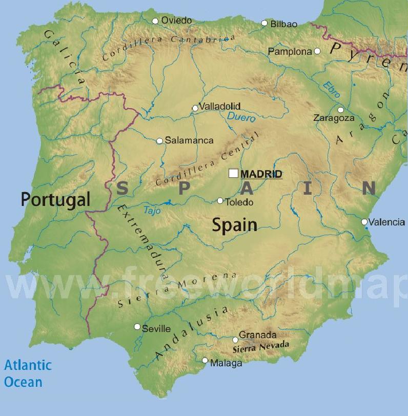
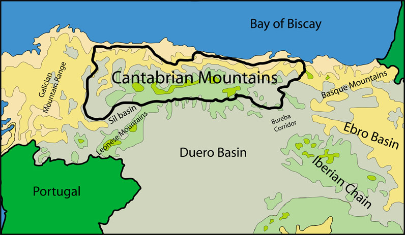
Most people who have been in northern Spain probably remember the Cantabrian Mountains, Cordillera Cantábrica in Spanish, as a mountain chain extending several hundreds of kilometers parallel to the north coast. But the exact length depends on the definition of the Cantabrian Mountains, while some authors prefer to let them begin where the Pyrenees end (map 1), this is at the border with France (which from a geologic viewpoint is certainly true), most consider both mountain chains separated by the Basque Mountains (map 2).
For the extended version, this is with the Basque Mountains included into the “Cordillera”, the total length is about 400+ kilometers. I personally prefer the second definition, in which case the Cantabrian Mountains reach from the Basque–Cantabrian border to just inside Galicia, extending for some 330 kilometers.

Map 1. This physical map shows the major mountains ranges of Spain, showing the Cantabrian Mountains to reach from the Galician Mountain Range in the west to the Pyrenees in the east.
Map 2. In this map the Cantabrian Mountains, here indicated as the Cordillera Cantábrica, are much more restricted. This map is a copy from www.freeworldmap.es.
Physical geographic context of the Cantabrian Mountains.
Because it seems there are no physical maps that accurately outline the precise extension of the Cantabrian Mountains, I have made a map which represents my personal interpretation based on abrupt topographic relief differences and geologic data. For example, the southern border with the Duero Basin exists of high uprising mountains above gently sloping plains (relief data). The mountains consist of paleozoic rocks, while the plains consist of tertiary rocks, which are the “waste” products of the erosion of the Cantabrian Mountains. The limit between both is almost always marked by deep and extensive thrustfaults (both geologic data). But these aspects will be treated with more details in the geological section. I used the term “abrupt topographic relief differences”, because absolute topographic height is not so useful in this case. For instance, in the south there are abrupt differences between absolute heights of approximately 1000 and 2000 meters (1000 meters of height difference), while along the coast there are differences between absolute heights of about 50 meters and 700 meters or more. As a matter of fact, coming from the south it is most impressive to see the abrupt thousand meter high wall which forms the southern border, caused by massive geological uplift.
At the north the Cantabrian Mountains are separated from the Cantabrian Sea by a narrow strip of lowland, although in some places they almost reach the coastline. For instance, just east of Ribadesella (Asturias) 750 m high mountain peaks are less than 3.5 km away from the shoreline. In the west and the east they are flanked by the Galician Mountain Range and the Basque Mountains respectively. To the south the most important feature is the Duero Basin (the term "basin" is used both in a hydrologic and geologic sense). In the south east they are limited by the Ebro Basin, which is separated from the Duero Basin by the Bureba Corridor, while in the south west we can find the small Sil Basin. A very small corridor separates the Cantabrian Mountains from the Leonese Mountains. Both basins and corridors are filled with tertiary sediments (mostly of Miocene age). For a visual representation see map 3.
At the north the Cantabrian Mountains are separated from the Cantabrian Sea by a narrow strip of lowland, although in some places they almost reach the coastline. For instance, just east of Ribadesella (Asturias) 750 m high mountain peaks are less than 3.5 km away from the shoreline. In the west and the east they are flanked by the Galician Mountain Range and the Basque Mountains respectively. To the south the most important feature is the Duero Basin (the term "basin" is used both in a hydrologic and geologic sense). In the south east they are limited by the Ebro Basin, which is separated from the Duero Basin by the Bureba Corridor, while in the south west we can find the small Sil Basin. A very small corridor separates the Cantabrian Mountains from the Leonese Mountains. Both basins and corridors are filled with tertiary sediments (mostly of Miocene age). For a visual representation see map 3.

Map 3. This self-made map outlines the Cantabrian Mountains in a physical context, see the text for explanation.
South of the Cantabrian Mountains map 3 shows some extensive areas with apparent high relief. In fact these are flat highlands with a height slightly above the 1000 meters, which are part of the Northern Meseta and which are clearly separated from the Cantabrian Mountains.
The map shows the major cities around the Cantabrian Mountains (Bilbao,Santander,Oviedo, Gijon, Lugo, Ourense, Ponferrada, León and Burgos) and also the major towns which directly surround the mountain limits. The roads that connect those towns most often are the fysical limits of the Cantabrian Mountains because they usually occupy the valleys floors and thus are topographic boundaries. This way it is possible to drive all around the "Cordillera Cantábrica" using roads which are very close by the indicated black line on the map.
Political geographic context of the Cantabrian Mountains.
As shows map 4, the Cantabrian Mountains extend over 5 communities and 7 provinces: the northern parts of León and Palencia, the north west of Burgos (all 3 provinces are part of the community of Castlla y León), almost the whole of Cantabria and Asturias and the eastern part of Lugo (Galicia). The width is about 60 to 70 kilometers, except for the western part where it reaches about 120 km.The map shows the major cities around the Cantabrian Mountains (Bilbao,Santander,Oviedo, Gijon, Lugo, Ourense, Ponferrada, León and Burgos) and also the major towns which directly surround the mountain limits. The roads that connect those towns most often are the fysical limits of the Cantabrian Mountains because they usually occupy the valleys floors and thus are topographic boundaries. This way it is possible to drive all around the "Cordillera Cantábrica" using roads which are very close by the indicated black line on the map.


Map 4. This self-made political map outlines the geographic position of the Cantabrian Mountains, see the text for explanation.
 Map 5 shows the three sectors or regions of the Cantabrian Mountains, of which the central region is the most extensive and with the highest peaks.
The three sectors of the Cantabrian Mountains.
The Cantabrian Mountains can be subdivided into three sectors: the eastern, central and western Cantabrian Mountains (map 5).Wild Flowers of the Cantabrian Mountains
OTHER FLORA OF THE CANTABRIAN MOUNTAINS:
The many names of the dandelion (Taraxacum officinale).
Flowers in March in the Cantabrian Mountains.
Subscribe to:
Posts (Atom)