Geographic location of the Cantabrian Mountains.
Most people who have been in northern Spain probably remember the Cantabrian Mountains, Cordillera Cantábrica in Spanish, as a mountain chain extending several hundreds of kilometers parallel to the north coast. But the exact length depends on the definition of the Cantabrian Mountains, while some authors prefer to let them begin where the Pyrenees end (map 1), this is at the border with France (which from a geologic viewpoint is certainly true), most consider both mountain chains separated by the Basque Mountains (map 2).
For the extended version, this is with the Basque Mountains included into the “Cordillera”, the total length is about 400+ kilometers. I personally prefer the second definition, in which case the Cantabrian Mountains reach from the Basque–Cantabrian border to just inside Galicia, extending for some 330 kilometers.

Map 1. This physical map shows the major mountains ranges of Spain, showing the Cantabrian Mountains to reach from the Galician Mountain Range in the west to the Pyrenees in the east.
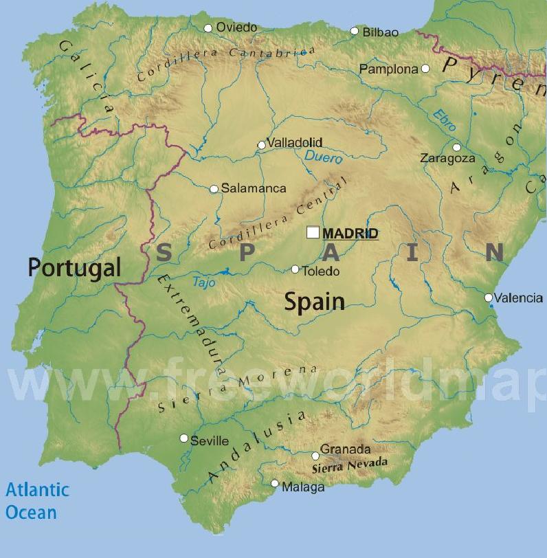
Map 2. In this map the Cantabrian Mountains, here indicated as the Cordillera Cantábrica, are much more restricted. This map is a copy from www.freeworldmap.es.
Physical geographic context of the Cantabrian Mountains.
Because it seems there are no physical maps that accurately outline the precise extension of the Cantabrian Mountains, I have made a map which represents my personal interpretation based on abrupt topographic relief differences and geologic data. For example, the southern border with the Duero Basin exists of high uprising mountains above gently sloping plains (relief data). The mountains consist of paleozoic rocks, while the plains consist of tertiary rocks, which are the “waste” products of the erosion of the Cantabrian Mountains. The limit between both is almost always marked by deep and extensive thrustfaults (both geologic data). But these aspects will be treated with more details in the geological section. I used the term “abrupt topographic relief differences”, because absolute topographic height is not so useful in this case. For instance, in the south there are abrupt differences between absolute heights of approximately 1000 and 2000 meters (1000 meters of height difference), while along the coast there are differences between absolute heights of about 50 meters and 700 meters or more. As a matter of fact, coming from the south it is most impressive to see the abrupt thousand meter high wall which forms the southern border, caused by massive geological uplift.
At the north the Cantabrian Mountains are separated from the Cantabrian Sea by a narrow strip of lowland, although in some places they almost reach the coastline. For instance, just east of Ribadesella (Asturias) 750 m high mountain peaks are less than 3.5 km away from the shoreline. In the west and the east they are flanked by the Galician Mountain Range and the Basque Mountains respectively. To the south the most important feature is the Duero Basin (the term "basin" is used both in a hydrologic and geologic sense). In the south east they are limited by the Ebro Basin, which is separated from the Duero Basin by the Bureba Corridor, while in the south west we can find the small Sil Basin. A very small corridor separates the Cantabrian Mountains from the Leonese Mountains. Both basins and corridors are filled with tertiary sediments (mostly of Miocene age). For a visual representation see map 3.
At the north the Cantabrian Mountains are separated from the Cantabrian Sea by a narrow strip of lowland, although in some places they almost reach the coastline. For instance, just east of Ribadesella (Asturias) 750 m high mountain peaks are less than 3.5 km away from the shoreline. In the west and the east they are flanked by the Galician Mountain Range and the Basque Mountains respectively. To the south the most important feature is the Duero Basin (the term "basin" is used both in a hydrologic and geologic sense). In the south east they are limited by the Ebro Basin, which is separated from the Duero Basin by the Bureba Corridor, while in the south west we can find the small Sil Basin. A very small corridor separates the Cantabrian Mountains from the Leonese Mountains. Both basins and corridors are filled with tertiary sediments (mostly of Miocene age). For a visual representation see map 3.
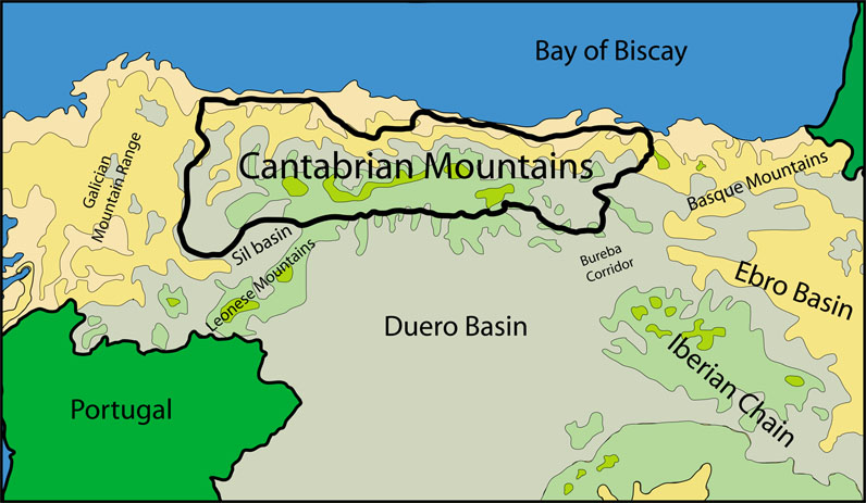

Map 3. This self-made map outlines the Cantabrian Mountains in a physical context, see the text for explanation.
South of the Cantabrian Mountains map 3 shows some extensive areas with apparent high relief. In fact these are flat highlands with a height slightly above the 1000 meters, which are part of the Northern Meseta and which are clearly separated from the Cantabrian Mountains.
The map shows the major cities around the Cantabrian Mountains (Bilbao,Santander,Oviedo, Gijon, Lugo, Ourense, Ponferrada, León and Burgos) and also the major towns which directly surround the mountain limits. The roads that connect those towns most often are the fysical limits of the Cantabrian Mountains because they usually occupy the valleys floors and thus are topographic boundaries. This way it is possible to drive all around the "Cordillera Cantábrica" using roads which are very close by the indicated black line on the map.
Political geographic context of the Cantabrian Mountains.
As shows map 4, the Cantabrian Mountains extend over 5 communities and 7 provinces: the northern parts of León and Palencia, the north west of Burgos (all 3 provinces are part of the community of Castlla y León), almost the whole of Cantabria and Asturias and the eastern part of Lugo (Galicia). The width is about 60 to 70 kilometers, except for the western part where it reaches about 120 km.The map shows the major cities around the Cantabrian Mountains (Bilbao,Santander,Oviedo, Gijon, Lugo, Ourense, Ponferrada, León and Burgos) and also the major towns which directly surround the mountain limits. The roads that connect those towns most often are the fysical limits of the Cantabrian Mountains because they usually occupy the valleys floors and thus are topographic boundaries. This way it is possible to drive all around the "Cordillera Cantábrica" using roads which are very close by the indicated black line on the map.


Map 4. This self-made political map outlines the geographic position of the Cantabrian Mountains, see the text for explanation.
 Map 5 shows the three sectors or regions of the Cantabrian Mountains, of which the central region is the most extensive and with the highest peaks.
The three sectors of the Cantabrian Mountains.
The Cantabrian Mountains can be subdivided into three sectors: the eastern, central and western Cantabrian Mountains (map 5).
The Basque Mountains are part of the Cantabrian Mountains
ReplyDelete